


1.jpg "Kennedy Hire")


 (2)1.jpg)


 (1).gif "DMG")


.jpeg "The Plant")


1.jpg "Last Call Spirits")


.jpeg)
.jpg "Tri State Parking Lot")

.jpg "Marler Probate Judge")


How Many More Times Cane We Dodge the Bullet
Matt BosterViewed: 4591
Posted by: Matt Boster
Date: Aug 18 2017 8:12 AM
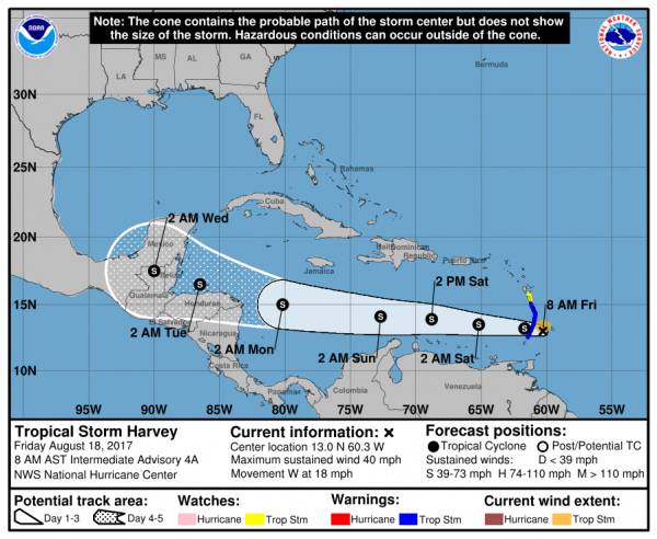
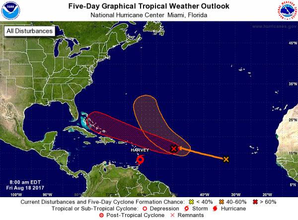
NHC is issuing advisories on Tropical Storm Harvey, located about 55 miles (90 km) west of Barbados at 8 a.m. AST (EDT). Maximum sustained winds remain near 40 mph (65 km/h) with higher gusts. Some slight strengthening is possible during the next 48 hours. The latest NHC advisory is linked at www.nhc.noaa.gov/#Harvey
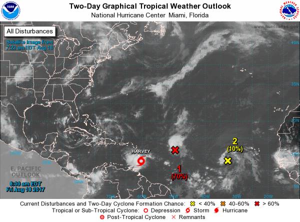
Elsewhere, we continue to closely watch an area of low pressure located about 750 miles east-northeast of the Leeward Islands. The shower and thunderstorm activity associated with it continues to show signs of organization. While it would take only a slight increase in organization for a tropical depression to form later today or tonight, upper-level winds are becoming less favorable for development. The low is expected to move west-northwestward at about 20 mph during the next few days, and interests in the northern Leeward Islands should monitor the progress of this disturbance. It has a high chance of becoming a tropical cyclone during the next five days.
Also, shower activity has increased during the last 24 hours in association with a tropical wave located over the far eastern Atlantic Ocean, several hundred miles west-southwest of the Cabo Verde Islands. Environmental conditions are forecast to become more favorable for some development early next week while the system moves west-northwestward to northwestward at about 20 mph. It has a medium chance of becoming a tropical cyclone during the next five days.
Get the latest on tropics by going directly to the NHC website at www.hurricanes.gov

<- back


.JPG "Wiregrass Electric")

1.jpeg)
.jpg "Harley Davidson")


1.jpg "Marler for Probate Judge")
.jpg "Last Call Spirits")


 (2).jpg)


.jpg "Kennedy Hire")


