


.jpg "Tri State Parking Lot")

 (2)1.jpg)


 (1).gif "DMG")


.jpeg "The Plant")

.jpeg)


1.jpg "Last Call Spirits")


1.jpg "Kennedy Hire")


.jpg "Marler Probate Judge")


Morning Weather Update for This Sunday
Matt BosterViewed: 5307
Posted by: Matt Boster
Date: Apr 10 2019 9:39 AM
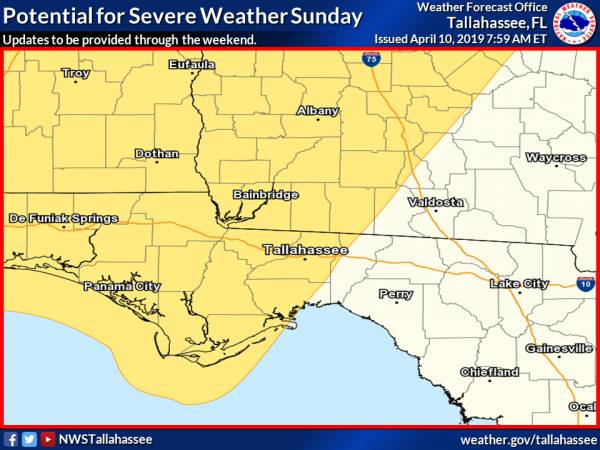
Its fairly significant whenever SPC has a severe weather risk beyond day 3 and I have attached the day 5 outlook which has the majority of the tri-state region in a threat area. As the threat falls on Sunday, we wanted to get the word out to everyone early for planning and notification purposes.
The medium range models are in good agreement in forecasting a potential squall line entering southeast Alabama and the western Florida panhandle in the late morning then progressing eastward with time reaching I-75 and the Florida Big Bend by late afternoon/early evening.
Please monitor for updates through the rest of the week as timing of this event could change.
THREATS: Damaging winds and isolated tornadoes will be the main threats.
TIMING: Beginning Sunday morning across SE AL and western FL panhandle and spreading east through the afternoon/evening hours.

<- back


 (2).jpg)


.JPG "Wiregrass Electric")


.jpg "Kennedy Hire")


.jpg "Harley Davidson")


1.jpeg)


1.jpg "Marler for Probate Judge")


.jpg "Last Call Spirits")


