


.jpg "Marler Probate Judge")
 (2)1.jpg)

 (1).gif "DMG")


1.jpg "Last Call Spirits")


.jpg "Tri State Parking Lot")


.jpeg)


.jpeg "The Plant")


1.jpg "Kennedy Hire")


National Weather Service Update
Matt BosterViewed: 5301
Posted by: Matt Boster
Date: May 22 2018 7:58 AM
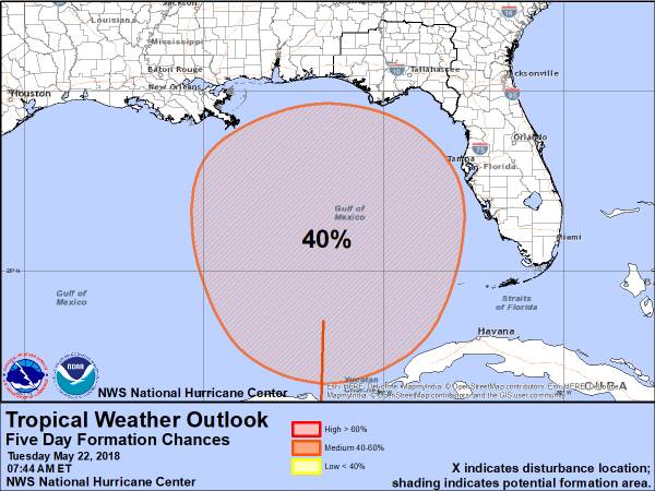
The National Hurricane Center has updated the Tropical Weather Outlook for an area of disturbed weather in the Caribbean and it now has a 40% chance of development. This is an increase in the chance of development as compared to yesterday morning.
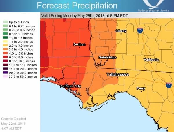
Regardless of whether this disturbance develops into a tropical system, the area will remain in a wet pattern over the next week and expect rainfall totals of 2-7" through Monday. Given these higher rainfall totals, the main threat over the next week will be flooding. With heavy rainfall and training of storms, isolated flash flooding will be possible the next few days, however we have held off on a flash flood watch due to the isolated nature of the flooding potential.
We will need to monitor this rainfall amounts and flood potential closely though over the next week.

<- back


.jpg "Harley Davidson")


.JPG "Wiregrass Electric")


.jpg "Kennedy Hire")


.jpg "Last Call Spirits")
 (2).jpg)

1.jpg "Marler for Probate Judge")


1.jpeg)


