


.jpg "Tri State Parking Lot")


.jpeg)


 (2)1.jpg)


1.jpg "Last Call Spirits")

.jpeg "The Plant")

1.jpg "Kennedy Hire")
.jpg "Marler Probate Judge")

 (1).gif "DMG")


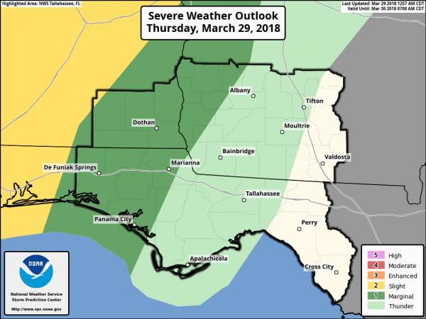
Weather Update
Matt BosterViewed: 7618
Posted by: Matt Boster
Date: Mar 29 2018 10:01 AM
A line of showers and thunderstorms associated with a cold front will move into the area from the west this evening, with scattered showers and isolated thunderstorms possible this afternoon ahead of the main line. A few strong to severe storms will be possible and thus the Storm Prediction Center has placed our western area under a "Marginal Risk" with a "Slight Risk" to our west (barely clips Coffee County, AL). The outlook graphic is attached.
Where: The best chances for any strong to severe storms will be across the western portion of our area, generally along and west of a line from Americus, GA to Marianna, FL to Panama City.
When: Late afternoon into tonight
Threats: The main threat remains isolated damaging wind gusts, although a tornado cannot be ruled out

<- back

.jpg "Last Call Spirits")


.JPG "Wiregrass Electric")


 (2).jpg)


1.jpeg)


.jpg "Kennedy Hire")


.jpg "Harley Davidson")


1.jpg "Marler for Probate Judge")


