


.jpg "Tri State Parking Lot")


1.jpg "Last Call Spirits")
.jpeg "The Plant")


 (2)1.jpg)


.jpeg)


1.jpg "Kennedy Hire")
.jpg "Marler Probate Judge")


 (1).gif "DMG")


Weather Update
Matt BosterViewed: 3159
Posted by: Matt Boster
Date: Aug 01 2018 3:07 PM
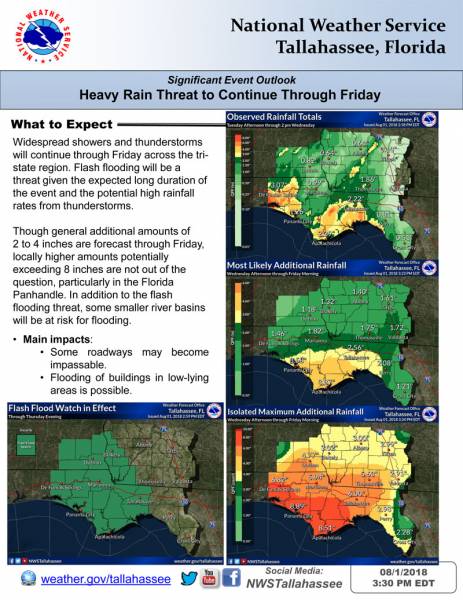
The threat for heavy rainfall continues into Friday across the region, particularly in the Florida Panhandle and Florida Big Bend. We’ve updated our briefing packet to include observed rainfall through this afternoon and our predicted additional rainfall.
Generally, we are anticipating an additional 2 to 4 inches of rain with isolated maximum totals up to 8 inches possible by Friday morning. This could result in storm total rainfall amounts up to 12 inches in some locations in the Florida Panhandle and Big Bend.
The flash flood watch is unchanged and remains in effect through Thursday evening.

<- back


.jpg "Kennedy Hire")


.jpg "Harley Davidson")
 (2).jpg)
.JPG "Wiregrass Electric")


1.jpg "Marler for Probate Judge")


1.jpeg)


.jpg "Last Call Spirits")


