


.jpeg "The Plant")


.jpeg)


1.jpg "Last Call Spirits")
.jpg "Marler Probate Judge")


.jpg "Tri State Parking Lot")

 (2)1.jpg)


1.jpg "Kennedy Hire")


 (1).gif "DMG")


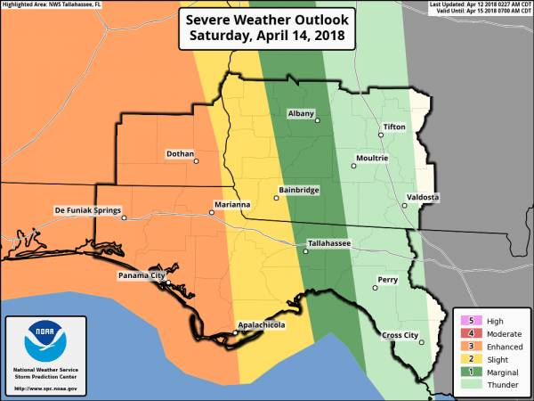
Enhanced Risk of Severe Weather This Weekend
Matt BosterViewed: 4692
Posted by: Matt Boster
Date: Apr 12 2018 9:19 AM
This is the latest from National Weather Service in Tallahassee.
The potential for severe weather this weekend remains on track, with the most likely time period from Saturday afternoon through Sunday morning. The Storm Prediction Center has issued an enhanced risk of severe thunderstorms across the FL Panhandle and southeastern Alabama during this period and decreasing severe risk farther east across our area. The latest risk graphic is attached below.
Two periods of strong/severe thunderstorms are possible with this event:
1) Scattered strong/severe thunderstorms are possible during the afternoon and evening across SE Alabama and the Florida Panhandle.
2) A squall line will likely move eastward across our entire area from Saturday night through Sunday morning. The main hazard will likely be damaging winds with this feature, but isolated tornadoes cannot be ruled out.
Some uncertainty remains regarding specific timing, intensity and other details, but we will continue to monitor the situation. We will keep you posted with emails, packets, and/or webinars as necessary as the event approaches. Feel free to contact us with any questions.

<- back


1.jpeg)
.jpg "Kennedy Hire")

1.jpg "Marler for Probate Judge")


.jpg "Last Call Spirits")


 (2).jpg)


.jpg "Harley Davidson")


.JPG "Wiregrass Electric")


