


.jpg "Tri State Parking Lot")


 (2)1.jpg)

1.jpg "Kennedy Hire")


1.jpg "Last Call Spirits")


.jpg "Marler Probate Judge")


 (1).gif "DMG")


.jpeg "The Plant")

.jpeg)


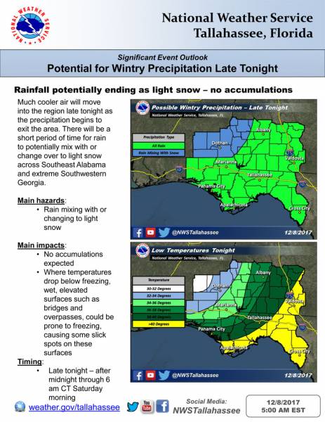
This is the latest from the NWS
Matt BosterViewed: 3795
Posted by: Matt Boster
Date: Dec 08 2017 9:25 AM
Main Changes: Lows tonight (Friday night) have increased a degree or two. Decreased area mentioned in the rain/snow mix.
Overview: The potential still exists for a brief period of a rain/snow mix or snow tonight across southeast Alabama and portions of southwest Georgia late tonight. With the warm ground and marginal air temperatures, little to no accumulation is expected. The main impact to watch for will be slick spots on any elevated surfaces such as bridges and overpasses.
Confidence: This event is highly dependent on how quickly the colder air moves in and the precipitation moves out of the area - there is still time for minor changes to the timing of the cold air/precipitation. Please do not focus too much on the exact rain vs. rain/snow mix area.

<- back


.JPG "Wiregrass Electric")

.jpg "Kennedy Hire")


 (2).jpg)
1.jpeg)


.jpg "Last Call Spirits")


1.jpg "Marler for Probate Judge")


.jpg "Harley Davidson")


