


1.jpg "Kennedy Hire")


 (1).gif "DMG")


.jpg "Tri State Parking Lot")


.jpeg)
1.jpg "Last Call Spirits")


.jpeg "The Plant")


.jpg "Marler Probate Judge")


 (2)1.jpg)


Hurricane Local Statement
Matt BosterViewed: 4606
Posted by: Matt Boster
Date: Oct 09 2018 8:40 AM
MICHAEL FORECAST TO BRING DEVASTATING IMPACTS TO THE GULF COAST AS
A MAJOR HURRICANE**
NEW INFORMATION
---------------
* CHANGES TO WATCHES AND WARNINGS:
- None
* CURRENT WATCHES AND WARNINGS:
- A Tropical Storm Warning and Hurricane Watch are in effect for
Clay, Coffee, Dale, Henry, Lee, Quitman, Randolph, and Terrell
- A Storm Surge Warning and Hurricane Warning are in effect for
Coastal Bay, Coastal Dixie, Coastal Franklin, Coastal Gulf,
Coastal Jefferson, Coastal Taylor, Coastal Wakulla, Inland
Franklin, Inland Gulf, Inland Wakulla, and South Walton
- A Hurricane Warning is in effect for Baker, Brooks, Calhoun,
Calhoun, Central Walton, Colquitt, Decatur, Dougherty, Early,
Gadsden, Geneva, Grady, Holmes, Houston, Inland Bay, Inland
Jefferson, Jackson, Leon, Liberty, Miller, Mitchell, North
Walton, Seminole, Thomas, Washington, and Worth
- A Tropical Storm Warning is in effect for Ben Hill, Berrien,
Cook, Inland Dixie, Inland Taylor, Irwin, Lafayette, Lanier,
Lowndes, Madison, Tift, and Turner
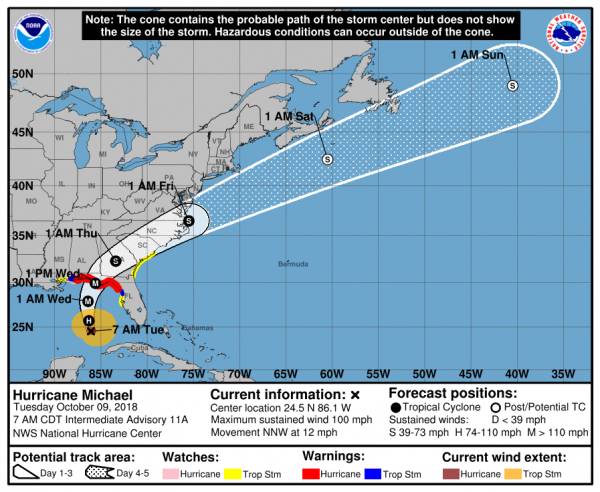
* STORM INFORMATION:
- About 420 miles south of PANAMA CITY or about 390 miles south
of APALACHICOLA
- 24.1N 85.9W
- Storm Intensity 90 mph
- Movement North-northwest or 345 degrees at 12 mph
SITUATION OVERVIEW
------------------
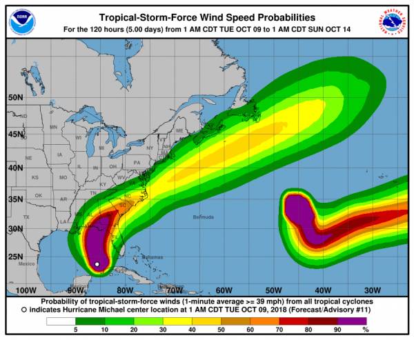
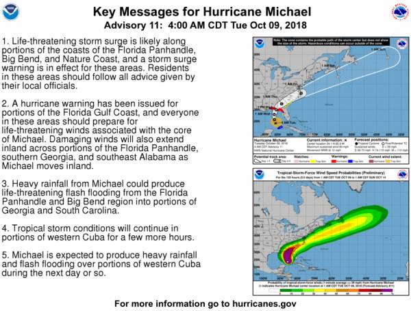
Very little change in expected impacts, intensity, or track of Michael with
the latest advisory. Hurricane Michael is still forecast to become a Major
hurricane prior to landfall. Deadly surge and devastating winds remain the
primary threats, especially closer to the coast from the central Big Bend
westward. Forecast rainfall amounts have increased into the 5-10" range,
with the greatest threat for dangerous flooding across the western Big
Bend and eastern Panhandle. A Flash Flood Watch is in effect for most
of the region. A few tornadoes are also expected, especially east of the
center of Michael. Impacts from all hazards could begin as early as late
this evening and peak on Wednesday.
POTENTIAL IMPACTS
-----------------
* SURGE:
Protect against life-threatening surge having possible devastating
impacts across the Big Bend coast, especially Apalachee Bay. Potential
impacts in this area include:
- Widespread deep inundation, with storm surge flooding greatly
accentuated by powerful battering waves. Structural damage to
buildings, with many washing away. Damage greatly compounded
from considerable floating debris. Locations may be
uninhabitable for an extended period.
- Near-shore escape routes and secondary roads washed out or
severely flooded. Flood control systems and barriers may become
stressed.
- Extreme beach erosion. New shoreline cuts possible.
- Massive damage to marinas, docks, boardwalks, and piers.
Numerous small craft broken away from moorings with many lifted
onshore and stranded.
Also, protect against life-threatening surge having possible
significant to extensive impacts across the Florida panhandle.
* WIND:
Protect against life-threatening wind having possible devastating
impacts across the Florida panhandle, western Big Bend, and extreme
southwest Georgia. Potential impacts in this area include:
- Structural damage to sturdy buildings, some with complete roof
and wall failures. Complete destruction of mobile homes. Damage
greatly accentuated by large airborne projectiles. Locations
may be uninhabitable for weeks or months.
- Numerous large trees snapped or uprooted along with fences and
roadway signs blown over.
- Many roads impassable from large debris, and more within urban
or heavily wooded places. Many bridges, causeways, and access
routes impassable.
- Widespread power and communications outages.
Also, protect against life-threatening wind having possible significant
to extensive impacts across the central Big Bend, south-central Georgia,
and southeast Alabama.
* FLOODING RAIN:
Protect against life-threatening rainfall flooding having possible
extensive impacts across the eastern Panhandle and western Big Bend.
Potential impacts include:
- Major rainfall flooding may prompt many evacuations and rescues.
- Rivers and tributaries may rapidly overflow their banks in
multiple places. Small streams, creeks, and ditches may become
dangerous rivers. Flood control systems and barriers may become
stressed.
- Flood waters can enter many structures within multiple
communities, some structures becoming uninhabitable or washed
away. Many places where flood waters may cover escape routes.
Streets and parking lots become rivers of moving water with
underpasses submerged. Driving conditions become dangerous.
Many road and bridge closures with some weakened or washed out.
Protect against dangerous rainfall flooding having possible limited
to significant impacts across much of southeast Alabama, south Georgia,
and the remainder of the Florida panhandle and Big Bend.
* TORNADOES:
Protect against a tornado event having possible limited impacts
across eastern Florida panhandle...Florida Big Bend...southeastern
Alabama and southwestern Georgia. Potential impacts include:
- The occurrence of isolated tornadoes can hinder the execution
of emergency plans during tropical events.
- A few places may experience tornado damage, along with power
and communications disruptions.
- Locations could realize roofs peeled off buildings, chimneys
toppled, mobile homes pushed off foundations or overturned,
large tree tops and branches snapped off, shallow-rooted trees
knocked over, moving vehicles blown off roads, and small boats
pulled from moorings.
PRECAUTIONARY/PREPAREDNESS ACTIONS
----------------------------------
* EVACUATIONS:
If evacuating, leave with a destination in mind and allow extra time to
get there. Take your emergency supplies kit. Gas up your vehicle ahead
of time.
* OTHER PREPAREDNESS INFORMATION:
Now is the time to complete all preparations to protect life and
property in accordance with your emergency plan. Ensure you are in a
safe location before the onset of strong winds or possible flooding.
Storm surge is the leading killer associated with tropical storms and
hurricanes! Make sure you are in a safe area away from the surge
zone. Even if you are not in a surge-prone area, you could find
yourself cutoff by flood waters during and after the storm. Heed
evacuation orders issued by the local authorities.
Closely monitor weather.gov, NOAA Weather radio or local news outlets
for official storm information. Be ready to adapt to possible changes
to the forecast. Ensure you have multiple ways to receive weather
warnings.
* ADDITIONAL SOURCES OF INFORMATION:
- For information on appropriate preparations see ready.gov
- For additional disaster preparedness information see redcross.org
NEXT UPDATE
-----------
The next local statement will be issued by the National Weather
Service in Tallahassee FL around 1130 AM EDT, or sooner if conditions
warrant.

<- back


.JPG "Wiregrass Electric")


1.jpg "Marler for Probate Judge")


1.jpeg)
.jpg "Kennedy Hire")


.jpg "Last Call Spirits")


.jpg "Harley Davidson")


 (2).jpg)


