1.jpg "Kennedy Hire")


.jpeg)


1.jpg "Last Call Spirits")


 (1).gif "DMG")


.jpg "Tri State Parking Lot")


.jpeg "The Plant")


.jpg "Marler Probate Judge")


 (2)1.jpg)


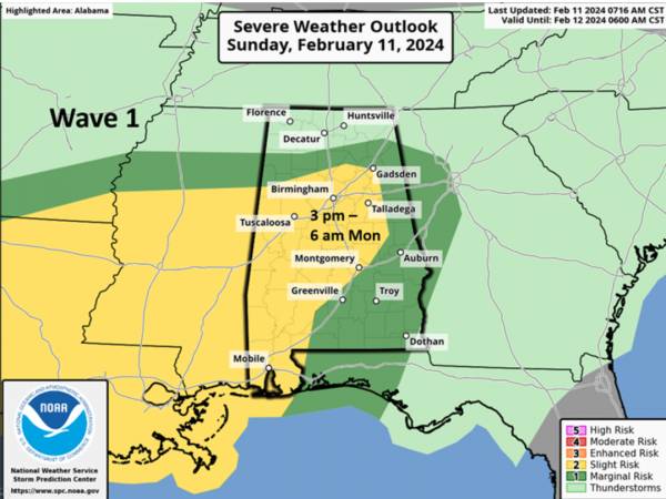
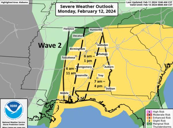
TWO WAVES OF RAIN AND POTENTIAL SEVERE WEATHER TODAY AND MONDAY
Rickey StokesViewed: 2843
Posted by: RStokes
[email protected]
Date: Feb 11 2024 10:32 AM
Two waves of showers and thunderstorms will occur through Monday. An area of rain with a few thunderstorms concentrated around I-20 is forecast to weaken during the remainder of the morning. From mid to late afternoon, an approaching upper level disturbance will lead to increased shower and thunderstorm activity statewide into early Monday morning.
Damaging wind gusts and hail are the main threats statewide, with a couple of tornadoes also possible in the Slight Risk area.
A second wave of thunderstorms is forecast beginning around 6 am Monday with activity ending in western Alabama by late morning and the southeastern sections by late afternoon. Damaging wind gusts and hail are the main threats, with a few tornadoes possible across the eastern half of the state.
From today through Monday afternoon, an additional 1-3 inches of rainfall is expected with locally higher amounts in stronger thunderstorms north of Hwy 80/I-85 and 1-2 inches south of this. Isolated flooding is possible through Monday morning north of I-20.
Finally, gusty northwest winds from 20-30 mph will occur behind the rainfall from Monday afternoon until around sunrise Tuesday.
We are entering our peak severe weather season. If you haven’t developed your severe weather plan or looked at it recently, now is the time to do so. Not being prepared and trying to figure out what to do during actual severe weather can lead to dire consequences.


<- back


1.jpeg)


.jpg "Kennedy Hire")


.jpg "Last Call Spirits")
.jpg "Harley Davidson")


 (2).jpg)


1.jpg "Marler for Probate Judge")
.JPG "Wiregrass Electric")